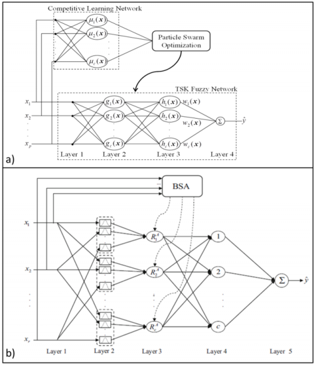
Modeling techniques capable to project shoreline position with the use of advanced Artificial Neural Networks (ANNs) are developed. Such techniques are applied in georeferenced metadata of the Autonomous Optical Monitoring System (AOMS) (e.g. TIMEX images), which are based in the use, development and optimization of specialised algorithms (e.g. Radial Basis Function Neural Network (RBFNN) - Competitive Learning Network (TSK-CLN)). During previous research efforts, and after appropriate training and comparison of the results of the several used ANNs, it was found that Root Mean Square Errors (RMSEs) gave good results (in some cases less than 3 m). Τhe developed ANNs will be extensively used in the optical and wave datasets deriving from the 2 pilot beaches. More specifically, 4 ANNs are being developed/tested which utilise different algorithmic approaches: 1) a Takagi-Sugeno-Kang network that includes the standard Backtracking Search Algorithm (ΤSK-BSA); 2) a 5-layer network which includes the same Backtracking Search Algorithm (NBN-BSA); 3) a 4-layer network which utilizes the Takagi-Sugeno-Kang structure together with a Competitive Learning Network (TSK – CLN); and 4) a neural network that utilize a Radial Basis Function( (RBFNN).
Τhe developed ANNs are applied/tested in synchronized timeseries of optical and wave data that include the following parameters: 1) Significant wave height (Hs); 2) peak wave period (Tp); 3) corrected sea level (SL); 4) wave run-up position; and 5) shoreline position at selected and equally distanced cross-shore sections. The dataset is divided in such a way so that 60% of it is used for training-testing of the networks, whereas the remaining 40% is used for projections. It has to be noted that simulation time is less than some seconds in all cases. Such innovative alternative modelling approaches are found to be very promising for the wider usage of such techniques in the complex coastal environments.

